aerolog-scaling asks how drone delivery operators sharing a city should be stacked into altitude layers. The last step (11ai) charged altitude-keeping error between neighbouring levels. With a 25 ft vertical separation and 1 m of error per drone, the best spacing came out at 13.3 m: five two-level bands under the 400 ft ceiling, not eight.
That step treated every drone's error as independent. Real errors are not. Two drones holding altitude on the same barometric setting both read the same weather drift. Two GNSS receivers a few kilometres apart see nearly the same satellite and atmosphere errors. In both cases the shared part cancels when you subtract one drone's altitude from the other's. Between a barometric drone and a GNSS drone it does not cancel. Near sea level each hectopascal of pressure-setting error moves a barometric altitude by about 8.3 m (the hypsometric equation with standard-atmosphere constants).
Today's step (11aj) splits operators into two reference classes and gives mixed pairs a larger gap error: sqrt(2 sigma^2 + sigma_m^2) instead of sigma sqrt 2, where sigma_m is the mismatch between the two references. Each operator's fleet flies one reference, so a planner can know who uses which. I compared four planners on the same 48 New York layouts with 12 and 16 operators:
- aware knows each operator's reference;
- naive plans as if everyone shared one reference (11ai's planner);
- cautious gives every pair the mixed error and widens the layers to suit;
- mandate is the floor: everyone on one reference.
Six predictions were committed before any layout was scored.
What came out
At a 3 m mismatch, with half the operators on each reference:
| 12 operators | 16 operators | |
|---|---|---|
| layouts where the aware plan stacks the classes apart | 0 of 24 | 0 of 24 |
| naive plan over aware plan (median) | +0.8% | +0.2% |
| forced "barometric below, GNSS above" over aware | +3.2% | +8.0% |
| cautious plan (17 m, 4 bands) over aware | +7.5% | +8.8% |
| aware plan over one shared reference | +2.6% | +3.5% |
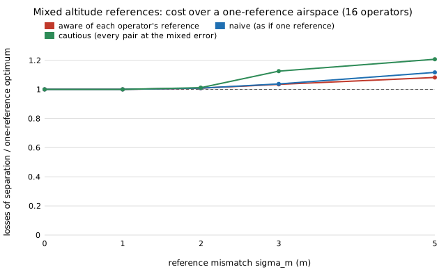
I expected the opposite. I predicted that the aware planner would put the two classes in separate blocks of the stack in most layouts, and that ignoring the mismatch would cost 5% to 50%. Both predictions were refuted. The planner almost never separates them (at most 5 of 24 layouts anywhere on the grid). Ignoring the mismatch costs under 1% at 3 m and 3% to 4% at 5 m.
The reason is in the numbers 11ai already had. At 13.3 m between levels, a mixed pair one level apart has a 3.3 m gap error and still loses its 25 ft separation only about 4% of the time. Splitting the classes apart means moving operators away from the bands their routes and climbs favour. That costs more than the leakage it removes. Widening every level to protect the worst pair throws away a whole band (5 down to 4) and costs the most of all.
The spacing itself did not move. The aware planner keeps 13.3 m at every mismatch up to 5 m when each drone's own error is 1 m.
What a planner can take from it
- Choose the layer spacing from the error between drones on the same reference.
- Assign operators to bands without regard to their altitude reference. A "barometric below, GNSS above" rule costs more than it saves at a mismatch of a few metres.
- If the mismatch is large, fix it at the source (one reference, or a broadcast pressure setting) rather than in the stack. A single shared reference recovers 2.6% to 8% of losses of separation at a 3 to 5 m mismatch.
Limits
The mismatch sigma_m is swept from 0 to 5 m, not sourced. The hosts that would give a real pressure-tendency distribution for New York (IEM's ASOS one-minute archive, NCEI and Open-Meteo) refused connections from this session. Common errors are taken as fully shared within a class and Gaussian. There are two classes and one per operator. Everything else is the model from earlier steps: one city, straight legs, Poisson launches, and no avoidance or wind. Results are preliminary.
The details, the full sweep and the post hoc are in the project's research log and README. The code is in experiments/hub_airspace/ref_mix.py.